Our Terms & Conditions | Our Privacy Policy
5 ways the world’s costliest satellite launch will reshape science: What ISRO-NASA collaboration means for future scientists
Sriharikota in India is all set to witness something extraordinary. The Indian Space Research Organisation (ISRO) and National Aeronautics and Space Administration (NASA) have joined forces to create what might be the most expensive piece of Earth-watching technology ever built. The NASA-ISRO Synthetic Aperture Radar satellite, known simply as NISAR, carries a price tag that would make most government treasuries wince; $1.5 billion.Set to take off on July 30 at 5:40 PM from Andhra Pradesh, this isn’t just another satellite launch. NISAR represents a quantum leap in how we observe and understand our planet’s every twitch and movement. For students dreaming of careers in space science or anyone fascinated by cutting-edge technology, this collaboration offers a glimpse into the future of planetary monitoring.The partnership between India’s space agency and America’s NASA marks a remarkable moment. What they’ve created together promises to revolutionise everything from disaster prediction to climate research, all whilst demonstrating what’s possible when brilliant minds from different continents work towards a common goal.
Earth’s surface to get the ultimate zoom in
NISAR’s winning trick lies in its twin synthetic aperture radars, which can spot surface changes measured in fractions of an inch. Think about that for a moment, from hundreds of kilometres above Earth, this satellite can detect movements smaller than the thickness of a coin. Whether it’s tracking ice sheets creeping across Antarctica or monitoring how land shifts after major earthquakes, NISAR sees it all.The satellite operates regardless of weather conditions or time of day, meaning clouds, rain, or darkness won’t interfere with its observations. This 24/7 capability makes it invaluable for monitoring rapidly changing situations like volcanic activity or landslides. Scientists will finally have a tool that never blinks, never sleeps, and never loses sight of Earth’s subtle transformations.
Disaster prediction will be changed forever
Natural disasters often leave subtle warning signs before they strike, and NISAR excels at reading these early signals. The satellite’s incredible sensitivity means it can detect tiny movements along fault lines that might indicate building seismic pressure. This capability could potentially save thousands of lives by providing earlier earthquake warnings.Beyond natural disasters, NISAR keeps watch over critical infrastructure that millions depend upon. Dams, levees, and major aqueducts face constant pressure from shifting ground beneath them. The satellite can spot microscopic changes in these structures’ foundations, alerting engineers to potential problems before catastrophic failures occur. It’s like having a highly trained inspector constantly monitoring every vital piece of infrastructure across the globe.
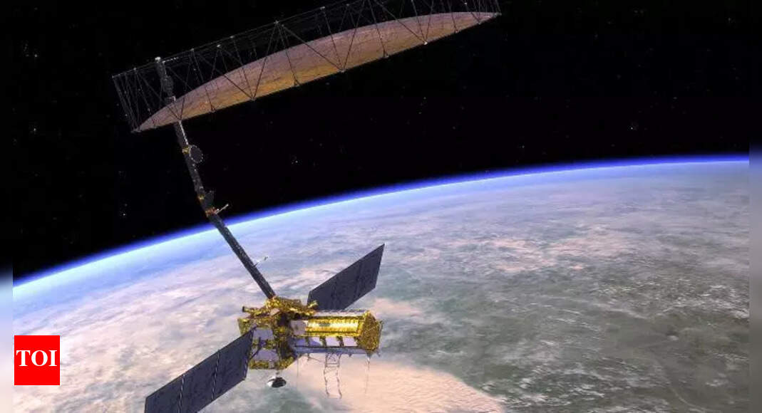
Technology that is making waves
At NISAR’s heart sit two sophisticated radar systems working in harmony. The L-band radar excels at penetrating various surfaces to measure moisture levels and detect movement, whilst the S-band radar specialises in surface analysis and crop monitoring. Together, they generate roughly 80 terabytes of information daily – that’s equivalent to storing about 16,000 high-definition movies every single day.This massive data stream gets processed and made available through cloud-based systems, meaning researchers worldwide can access real-time planetary information almost instantly. The technological achievement represents years of engineering innovation, combining advanced radar design with sophisticated data processing capabilities that would have been impossible just a decade ago.
Earth’s ecosystems to get the attention they deserve
Forests, wetlands, agricultural regions, and other ecosystems will experience unprecedented monitoring through NISAR’s advanced sensors. The L-band radar can peek through dense forest canopies to analyse tree structure and health, providing insights into deforestation rates and forest recovery patterns. Meanwhile, the S-band radar tracks agricultural productivity and crop health across different seasons.Every 12 days, NISAR completes a full scan of Earth’s surface, creating a constant cycle of observation that captures both gradual changes and sudden shifts in ecosystem health. This regular monitoring will help scientists understand how climate change affects different environments and how human activities impact natural systems worldwide.
International cooperation just witnessed a new high
This satellite represents something genuinely historic in space exploration – the first major collaborative project between ISRO and NASA. Engineers from both organisations worked together to combine their respective strengths, with India’s Space Applications Centre building the S-band radar whilst NASA’s Southern California facility developed the L-band system.The integration process required merging these separately built components into ISRO’s modified I3K spacecraft platform, creating a technological marriage that showcases both agencies’ capabilities. This collaboration model could become a template for future international space projects, demonstrating how shared expertise and resources can achieve results that neither organisation could accomplish alone.The success of this partnership might encourage other nations to pursue similar collaborative approaches to space exploration, potentially accelerating scientific discovery whilst sharing the enormous costs associated with cutting-edge space technology.NISAR stands as more than just an expensive satellite; it’s proof that international cooperation can produce extraordinary results. For students considering careers in space science, climate research, or disaster management, this project illustrates the exciting possibilities that emerge when different cultures and scientific traditions combine their knowledge and resources. The satellite will spend years gathering data that could reshape our understanding of Earth’s complex systems, making this launch a pivotal moment in planetary science history.
Images are for reference only.Images and contents gathered automatic from google or 3rd party sources.All rights on the images and contents are with their legal original owners.
Aggregated From –
Comments are closed.