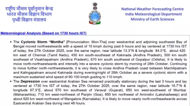
A severe weather situation is unfolding along India’s east coast as the India Meteorological Department (IMD) issues escalating alerts for the states of Andhra Pradesh and neighbouring coastal regions. The cyclonic storm known as Cyclone Montha, currently spinning over the Bay of Bengal, is forecast to make landfall by Tuesday (October 28) evening or night and is intensifying quickly.The IMD reports that Montha is likely to cross the Andhra Pradesh coast between Machilipatnam and Kalingapatnam, near Kakinada, during the evening or night of October 28, classified as a “severe cyclonic storm” with maximum sustained wind speeds of 90-100 km/h, gusting to 110 km/h.
 According to the bulletin:
- The system is expected to intensify into a severe cyclonic storm by October 28.
- The track forecast indicates a west-northwest to north-northwest movement.
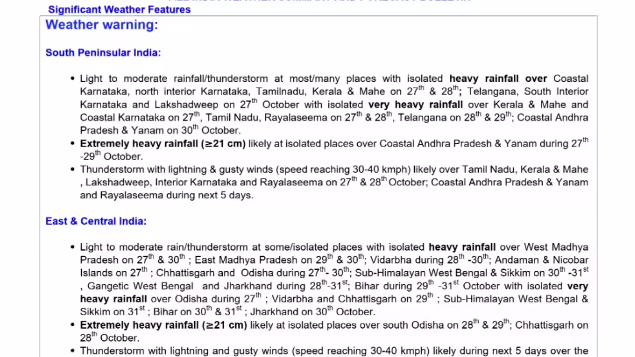
- Heavy to very heavy rainfall and strong winds are expected in coastal Andhra Pradesh, with the potential for isolated extremely heavy rainfall.
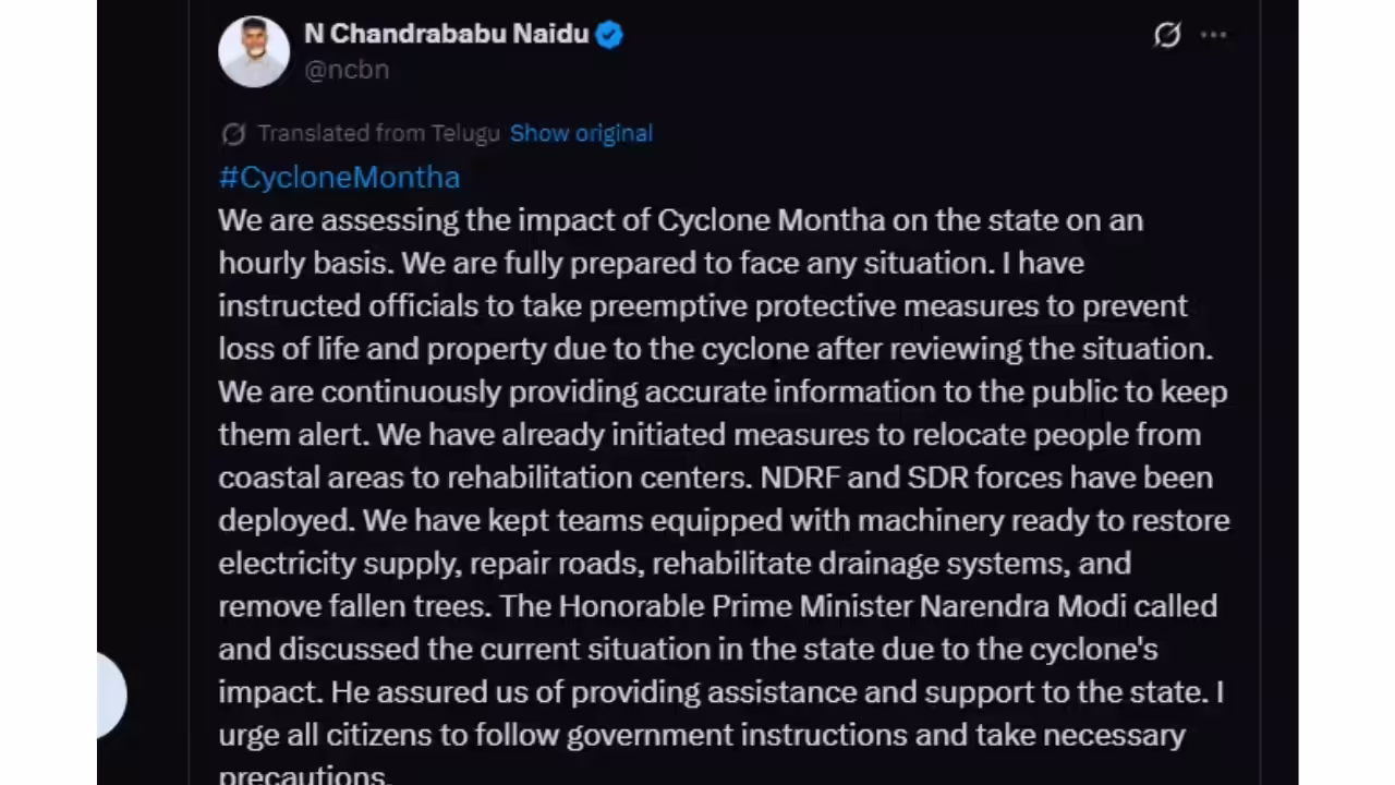
Andhra Pradesh state authorities have ramped up operations in anticipation of the storm. The state’s Chief Minister N. Chandrababu Naidu directed officials from the Real-Time Governance Centre to remain on high alert, deploy disaster response teams, monitor communications and evacuations, and ensure relief camps are in readiness. Evacuations are already under way, with thousands of people moved from low-lying coastal zones. The central government has also been notified, and the Prime Minister has been in touch with state officials.
 Although the direct hit is projected for Andhra Pradesh, neighbouring Odisha is carefully monitoring the situation. The state has declared ‘red-alert’ zones in several coastal districts and is preparing rescue and relief mechanisms in case the system shifts or intensifies further.Fishermen have been advised against venturing into the Bay of Bengal due to rough seas and rising winds. Coastal regions are on watch for storm surge, high tides, water-logging, and wind-borne debris hazards.The IMD’s forecast includes heavy to very heavy rainfall in a short period, raising the prospect of urban flooding, overflowing drains, inundated agricultural fields, and riverine flooding in low-lying coastal belts. Residents in the coastal belts of Andhra Pradesh (especially around Kakinada, Machilipatnam, Kalingapatnam) should immediately follow evacuation orders, avoid venturing out during gale-force winds, and stay away from beaches and exposed coastal zones.
Advisory for tourists and residents
For tourists currently visiting coastal Andhra Pradesh, Odisha, or nearby regions, authorities strongly advise postponing all travel plans until Cyclone Montha has fully dissipated. Tourist beaches across Visakhapatnam, Kakinada, and Machilipatnam have been closed, and boat rides or water sports are suspended for safety. Travellers should avoid venturing near the coastlines or riverbanks, as the sea is extremely rough and storm surges could inundate low-lying areas. Those staying in hotels or resorts are urged to remain indoors, follow local advisories, and stay updated through the India Meteorological Department’s official website and state disaster management bulletins. Transportation, including train and flight schedules, may face delays or cancellations, so it’s advisable to confirm all bookings before travel.Tourists and locals alike are urged to remain patient and prioritise safety over movement during this period of severe weather. The IMD continues to monitor Cyclone Montha closely and will issue timely updates as the situation evolves.
Cyclone Montha recap: What we know so far
Cyclone Montha is advancing steadily toward the Andhra Pradesh coast, predicted to make landfall between Machilipatnam and Kalingapatnam around Kakinada during the evening or night of Tuesday, October 28. The IMD forecasts wind speeds of 90-100 km/h with gusts up to ~110 km/h, heavy to very heavy rainfall, and significant coastal and inland flooding risk. Authorities in Andhra Pradesh and Odisha are mobilising evacuation, relief and response operations. Residents in low-lying and coastal zones must heed official orders, take shelter, stay indoors during the peak window, and avoid venturing into rough seas or flood-prone areas.As always, the IMD’s bulletins are the authoritative source and should be monitored closely for updates. The evolving nature of cyclones means that forecasts will be refined as the system progresses; local administrations must remain agile in their response. For Montha, the next 24 hours are absolutely critical. Landfall is imminent, and coastal regions are entering the high-impact window.
Images are for reference only.Images and contents gathered automatic from google or 3rd party sources.All rights on the images and contents are with their legal original owners.