Our Terms & Conditions | Our Privacy Policy
How the Wyoming Landscape Conservation Initiative has fostered two decades of conservation in the checkerboard
By Emma Dietrich and Patrick Anderson
“The checkerboard is always in the back of our minds” says Jim Wasseen, Wyoming Landscape Conservation Initiative coordinator for the Wyoming Game and Fish Department. The alternating pattern of private and public land ownership that crosses Wyoming was created in the 1800s when the federal government deeded every other square mile of land to railroad companies as they expanded tracks across the West, and has long posed a problem to land managers in the region.
Today, a few companies own and lease most of the private lands in the checkerboard and use that land primarily for mining, energy development, and grazing sheep and cattle. The Bureau of Land Management (BLM) manages most of the public portions of the checkerboard for multiple uses, including conservation, recreation, ranching, and mineral extraction. Other landowners and managers include private individuals, the state of Wyoming, and other federal agencies.
Each landowner has their own goals and needs for the land, and ignoring what happens on neighboring lands is not always an option. Everything from rivers and mineral deposits to the wildlife that Wasseen is responsible for managing can cross land management boundaries, so what happens on one plot influences neighboring lands. In southwest Wyoming—a region the size of South Carolina with the world’s largest trona reserve, significant coal and uranium production, considerable oil and natural gas reserves, vital freshwater tributaries of the Colorado River, valuable game species, essential wildlife habitat, and acres of prime land for ranching, recreation, and renewable energy development—the challenge of balancing different landowners’ needs is never-ending.
The Wyoming Landscape Conservation Initiative (WLCI), a coalition of federal, state, and local government agencies and nongovernmental organizations, has answered this challenge with a program driven by partnerships and supported by science. This combination has proved valuable and nimble enough to endure for nearly 20 years of facilitating landscape-scale conservation and responsible development in southwest Wyoming, while producing research, technology, and management models that are transferable to other landscapes facing similar problems.
Land ownership and administrative boundaries within the Wyoming Landscape Conservation Initiative (WLCI). Along the Union Pacific Railroad, land ownership alternates mile-to-mile in a checkboard pattern, primarily between private land owners and the Bureau of Land Management. (Emma Dietrich/USGS)
WLCI arose in the 2000s, not long after rediscovery of two of the nation’s largest natural gas fields in southwestern Wyoming spurred a rapid rise in demand for energy development and related industries. This growing demand, combined with urban development, worsening drought, and the spread of invasive species in the region, conflicted with other land uses, like ranching and outdoor recreation, and jeopardized overall landscape integrity.
To balance conflicting land management priorities—that is, to allow for development while conserving lands for other uses—interested federal, state and local governments established WLCI through a cooperative agreement and began drafting plans for its operations. Key to these plans was the development of distinct committees and teams, each assigned a clear function within the coalition. The WLCI Executive Committee, composed of local, state, and federal government executives and elected officials, is responsible for setting the strategic direction and policies of the initiative. To facilitate that strategic vision, the WLCI Coordination Team manages the daily operations of WLCI, including regular interactions with the public and partners at the field level. The US Geological Survey’s dedicated WLCI Science Team conducts research to better understand and address the ecological and environmental challenges facing managers within the WLCI landscape.
With these three teams working together, the founders hoped to improve the efficacy of on-the-ground conservation projects—like fencing improvements, wetland creation, river restoration, prescribed burns, weed treatments, and habitat protection—by giving them a collaborative, landscape focus and basing management decisions in science. Renee Dana, retired WLCI coordinator for BLM Wyoming and founding member of WLCI describes how the WLCI executives provided momentum in those early days. “Their commitment, along with great support from local governments and partners, brought WLCI to life.”
Early congressional funding for WLCI provided the means for federal agencies to begin work in public portions of the region, but to implement meaningful, landscape-scale change required local buy-in. For example, BLM could begin treating invasive species or restoring fish habitat on their portions of land, but invasive species treatments would not be successful long-term if every other square mile of land still contained the invaders. And removing barriers to fish passage in a stream on public land would only improve fish movement if there were not similar barriers in the next mile along the same stream.
 Together, the Saratoga-Encampment-Rawlins Conservation District and Wyoming Game and Fish Department performed a number of river restoration projects along the North Platte and Encampment Rivers, including replacing old irrigation structures with new ones that allow for fish passage and improve sediment transport throughout the watershed. (Jim Wasseen/Wyoming Game and Fish Department)
“Landscape health knows no boundaries,” says Mary Jo Rugwell, retired BLM Wyoming state director and former WLCI executive. “People must find common ground and work toward the goal of improving the lands together.” To reach their landscape-scale goals, WLCI executives and coordinators needed to consider all possible owners, resources, and jurisdictions, meaning many people with potentially conflicting needs would have to jointly decide which actions to implement on public and private lands.
To meet this need, WLCI coordinators organized Local Project Development Teams representing the five largest counties overlapping the WLCI area— Sublette, Sweetwater, Carbon, Lincoln, and Uinta. Resource specialists from federal, state, and county agencies and nongovernmental organizations joined the local team meetings. WLCI executives from conservation district and county commissioner offices leveraged their networks to increase local government and private landowner participation. “Alone, we manage landscapes, but only for one component,” says Chris Aimone, Uinta County Weed and Pest supervisor and Uinta local team member. “WLCI brought so many players to the table, different organizations coming together to look at the whole landscape.”
 A Montana Conservation Corps crew converts old barbed- and mesh-wire fence to wood post, rail-top, and wire fence on Ferris Mountain. (BLM)
The local teams were tasked with developing common goals and priorities that addressed conservation challenges across southwestern Wyoming, including in the checkerboard. To accomplish this, the WLCI Coordination Team ran local forums facilitated by the University of Wyoming’s Ruckelshaus Institute that encouraged public participation and explored how individual goals and priorities could align with WLCI’s broader vision. Throughout the processes, WLCI coordinators tried to make it clear they weren’t trying to tell local practitioners what to do.
Building relationships and trust took time, but it was a necessary first step to starting WLCI off on the right foot and has paid off time and again. “It always amazed me when people working for differing agencies or employers had the realization that, by sharing their plans and needs for their area of concern, it could often lead to less duplication of effort,” says Justin Caudill, agriculture program coordinator for the Wyoming Department of Agriculture and WLCI coordinator. These partnerships, he says, allow “the local team to cultivate and develop a project into a truly landscape effort affecting many wildlife species and agriculture with vastly positive outcomes.”
To ensure that a grassroots approach to conservation is sustained over time, the local teams develop and vote on priority habitats and project proposals within and across their counties each year. Then, the WLCI coordinators rank projects according to how well each fit with prior work across the WLCI region, as well as the conservation goals formulated by the local teams during WLCI’s establishment. The Coordination Team sends their recommendation to the Executive Committee, which gives final approval and determines how much funding to grant each of the top-ranked projects. After that, it returns to the local teams for implementation.
“It’s better if agencies fund projects, then let the communities drive the projects, as the communities know the locals and who to hire,” says Rox Hicks, retired US Fish and Wildlife Service biologist and WLCI coordinator. The local teams bring in external grants and matching funds from members’ own agencies or organizations, which gives them more flexibility to work across jurisdictional and ownership boundaries of all interested parties. Rox says that “what has worked for WLCI is fitting together the big puzzle—including the checkerboard, private landowners, finding matching monies, and who wants to get things done together.”
 Sublette County Conservation District installed a solar-powered well pump and tire tanks to provide water for cattle. The location of of these tanks improve range conditions by better distributing cattle across a grazing allotment. (Jim Wasseen/Wyoming Game and Fish Department)
In addition to external funding, the local team members leverage external relationships to get conservation work done. One particularly important relationship is with the Rock Springs Grazing Association (RSGA). A large organization of cattle and sheep ranchers recognized for its landscape stewardship, the RSGA leases lands from the major energy companies in the checkerboard and is permitted to use much of the connecting public sections for winter grazing. This means they essentially manage a large swath of the checkerboard as one unit and can facilitate projects across that entire unit. Though RSGA is not an official partner of WLCI, many local team members independently collaborate with the grazing association, and a lot of WLCI’s success relies on groups like the RSGA serving as a network hub to implement restoration and habitat improvement projects.
Also integral to project development and execution is the US Geological Survey (USGS) Science Team. After all, “without sound science to help managers decide best options, how do they implement projects with lasting benefits?” asks Wyoming Game and Fish’s Wasseen. Over the years, the USGS has produced over 200 different scientific products for WLCI partners and local teams on topics of management interest like mineral distribution and abundance, wildlife migration, vegetation status and trends, ecosystem restoration, water quality, land management economics, and invasive species biology. Scientists present new products and get feedback on ongoing work during WLCI-hosted workshops and virtual meetings, field tours with WLCI partners, and at local team meetings. Subsequently, local team members use applicable science to inform projects and prioritize management actions. Coordinators and executives also use USGS science to measure the impact of local team management actions on broader conservation goals.
Southwestern Wyoming’s mix of world-class wildlife, priority habitats, and development in and outside of the checkerboard has created a unique place for scientists to develop products that are applicable across jurisdictional boundaries and address large landscape decisions. Indeed, many science projects piloted within WLCI, like the mapping of ungulate movement and migration corridors, have now expanded across much of the western United States. This mapping has helped managers determine where to construct wildlife-friendly fencing and habitat improvements in southwestern Wyoming and beyond.
 Jason Alexander, a former fluvial geomorphologist with the USGS Wyoming Montana Water Science Center, explains to the WLCI Executive Committee how he used sediment traps to evaluate sediment deposition in Carbon County’s Littlefield Creek. (Patrick Anderson/USGS)
Despite the success of WLCI’s collaborative management and learning model, maintaining WLCI core teams across two decades has not been easy. Employee turnover within organizations, major private land sales in the region, and shifting organizational priorities have all challenged WLCI’s success. Aimone, with Uinta County Weed and Pest, says that “in areas with new owners, it can be difficult to figure out who to contact and how to get their buy-in.” Historically, many partners in WLCI were local to the region, either living or headquartered within southwestern Wyoming. Most participants already shared a common interest in maintaining healthy landscapes across the region. Recently, some of the private lands in the checkerboard were sold to large corporations without a local presence beyond ownership, and engaging them in the initiative has been challenging.
Wasseen, and others, emphasized that maintaining relationships, interest, and enthusiasm requires “getting our message out, and continuing to get our message out” through existing and new partnerships. “WLCI has been a constant, evolving effort. We are always needing to find ways to stay relevant within our own agencies and to others in southwest Wyoming,” he says. To do this, WLCI coordinators have organized many workshops, field tours, and meetings for different partners to share their work with each other and with potential new partners. In all, WLCI relies heavily on all members to leverage their personal networks within the region, and especially those of the local teams.
Indeed, to remain successful in the checkerboard and beyond, WLCI executives, coordinators, and local teams find motivation in the initiative’s foundational elements—landscape-scale conservation goals, strong partnerships, locally driven projects, and science-based decision making—while remaining flexible to shifting landscapes and individual needs. “There is no one way to get landscape-scale conservation done and some of the challenges to landscape-scale conservation are not a single fix,” says Dana, the retired WLCI coordinator for BLM Wyoming. “Continuously overcoming challenges and remaining flexible are an integral part of the structure and organization.”
Emma Dietrich is a biologist with the USGS Fort Collins Science Center. She develops communications for USGS science teams and completes research in support of bridging the research-management gap.
Patrick Anderson leads the USGS Science Team in support of WLCI and serves on the WLCI Coordination Team. His science focuses on evaluating the effectiveness of habitat treatments and restoration of sagebrush and aspen communities. He is also interested in advancing collaborative conservation partnerships, improving stakeholder engagement, and developing approaches to advance the co-design and coproduction of science to make it more accessible and usable.
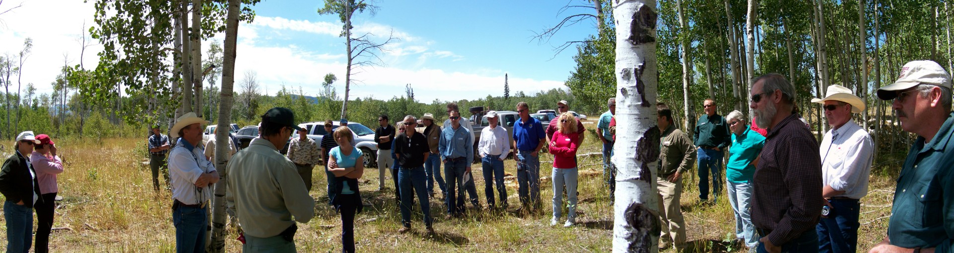
Header image: The WLCI Executive Committee and staff tour a tree removal project where old, decaying aspen and other vegetation were removed, piled, and later burned with the goal of regeneration of new aspen growth. (Justin Caudill/Wyoming Department of Agriculture)
Images are for reference only.Images and contents gathered automatic from google or 3rd party sources.All rights on the images and contents are with their legal original owners.
Aggregated From –
Comments are closed.