Our Terms & Conditions | Our Privacy Policy
Turkish scientists conducted observations and measurements on atmospheric and oceanic systems during scientific research expeditions to the North and South Poles.
Under the auspices of the Presidency and coordinated by TÜBITAK MAM Polar Research Institute (KARE), with responsibility assigned by the Ministry of Industry and Technology, the 5th National Arctic Scientific Research Expedition conducted extensive scientific data collection from the atmosphere to ocean depths.
During the expedition, an automatic meteorological observation station was established for the first time on the inter-polar line, enabling atmospheric data to be recorded regularly throughout the journey.
Using GNSS signals, researchers studied the amount of water vapor in the atmosphere and the interactions between the atmosphere and the ocean. Physical and chemical changes in different glacier regions were observed through water and ice sampling.
Additionally, oceanographic measurements and underwater sound velocity analyses of the ocean floor were conducted, providing crucial scientific data on global-scale processes, including climate change and sea level variations.
In an evaluation shared with Anadolu Agency (AA), Associate professor Erhan Arslan, Deputy Scientific Leader of the 5th National Arctic Scientific Research Expedition, stated: “We installed an automatic meteorological observation station on the ship for the first time. At regular intervals, we will measure meteorological parameters from different points spanning from the Arctic to the Antarctic. This will provide us with meteorological data covering the entire expedition, from the North Pole to the South Pole.”
Arslan added that these data will serve as an inventory for the atmosphere, helping to determine measurement points and improving the execution of future expeditions.
He also highlighted that the project “Modeling the atmosphere and the atmosphere-ocean relationship using GNSS signals to measure water vapor in an atmospheric column” allowed for continuous measurement of atmospheric dynamics during the expedition.
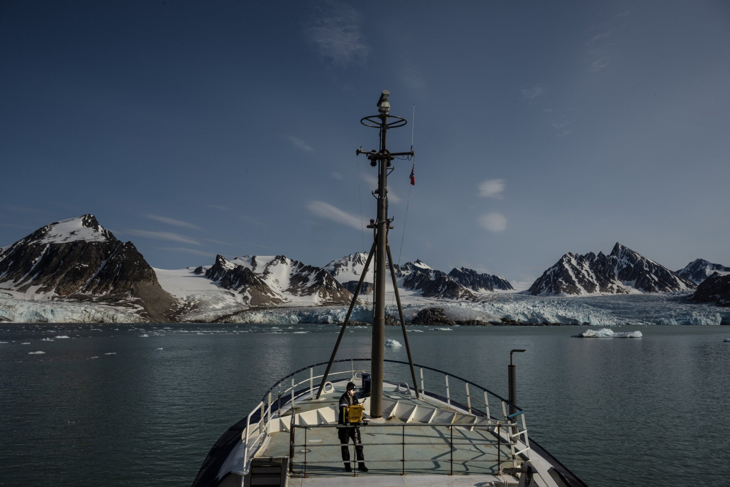
Research vessel sailing through polar waters during the 5th National Arctic Scientific Research Expedition, operated by Turkish scientists, Arctic and Antarctic regions, July 13, 2025. (AA Photo)
He emphasized, “This represents an important step for calculating water vapor and other gases in an atmospheric column. Combining measurements from the North Pole to the South Pole will provide us with a huge dataset internationally.”
Arslan stressed the necessity of obtaining these parameters to understand better climate change: “The increase of water vapor in the atmospheric column can be cited as a cause of global warming. Additionally, measuring other atmospheric components like temperature, humidity, wind and pressure will provide information about their future effects.”
He also added, “However, this needs to be conducted over a long period. By continuing the monitoring project we started during this expedition in future expeditions and analyzing the data over time, we will be able to discuss climate change more comprehensively.”
Dr. Adil Enis Arslan from Istanbul Technical University’s Department of Geomatics Engineering participated in this year’s expedition, performing highly accurate GNSS measurements at one-second intervals. These measurements focused on analyzing the relationship between the atmosphere and the ocean, ensuring the continuity of data and providing precise location valuable information for other scientific projects.
In addition to his own work, Arslan collected water and ice samples for two other university projects. These studies aim to clarify how the atmosphere interacts with GPS signals and to understand the impacts of global warming better.
They also focus on detecting micro-pollutants and heavy metals in polar waters, while improving the calibration of water and satellite imagery.
Arslan emphasized the critical importance of conducting these studies regularly, ideally annually. He explained that periodic observations from the same regions create valuable datasets that enable predictions and help fill in data gaps that occur between measurements.
Moreover, combining measurements from both the Arctic and Antarctic allows scientists to model relationships between different glacier regions more effectively.
Naval Captain Mustafa Kanat, serving as the 2nd Measurement Unit Commander at the Navigation, Hydrography and Oceanography Department of the Turkish Naval Forces, expressed pride in representing Türkiye and the Turkish Naval Forces in the Arctic.
He recalled Mustafa Kemal Atatürk’s vision, stating the importance of maritime activities as a national ideal and highlighting how this legacy inspired their efforts in the harsh Arctic environment.
Kanat detailed their involvement in the project, which measured oceanographic parameters in the Arctic. Their work included underwater sound velocity and water transparency measurements, which form the mathematical foundation for hydrographic surveys using multibeam sonar systems.
He explained that the data helps estimate how deep signals from satellites or aerial vehicles can penetrate water, depending on signal frequency. Kanat added that the data collected this year will expand their database, enabling comparisons of changes over time and improving their calculation models.
Recognizing the Arctic as one of the world’s most challenging maritime and meteorological environments, Kanat stressed the importance of gaining experience in navigation and observation under such extreme conditions. He concluded by expressing the team’s commitment to making the best possible contributions to Türkiye during the expedition.

The Daily Sabah Newsletter
Keep up to date with what’s happening in Turkey,
it’s region and the world.
SIGN ME UP
You can unsubscribe at any time. By signing up you are agreeing to our Terms of Use and Privacy Policy.
This site is protected by reCAPTCHA and the Google Privacy Policy and Terms of Service apply.
Images are for reference only.Images and contents gathered automatic from google or 3rd party sources.All rights on the images and contents are with their legal original owners.
Aggregated From –
Comments are closed.