Our Terms & Conditions | Our Privacy Policy
What is The Salt Path and can I hike it? As the much-anticipated movie hits the big screens we look at the iconic UK hiking trail that provides its setting
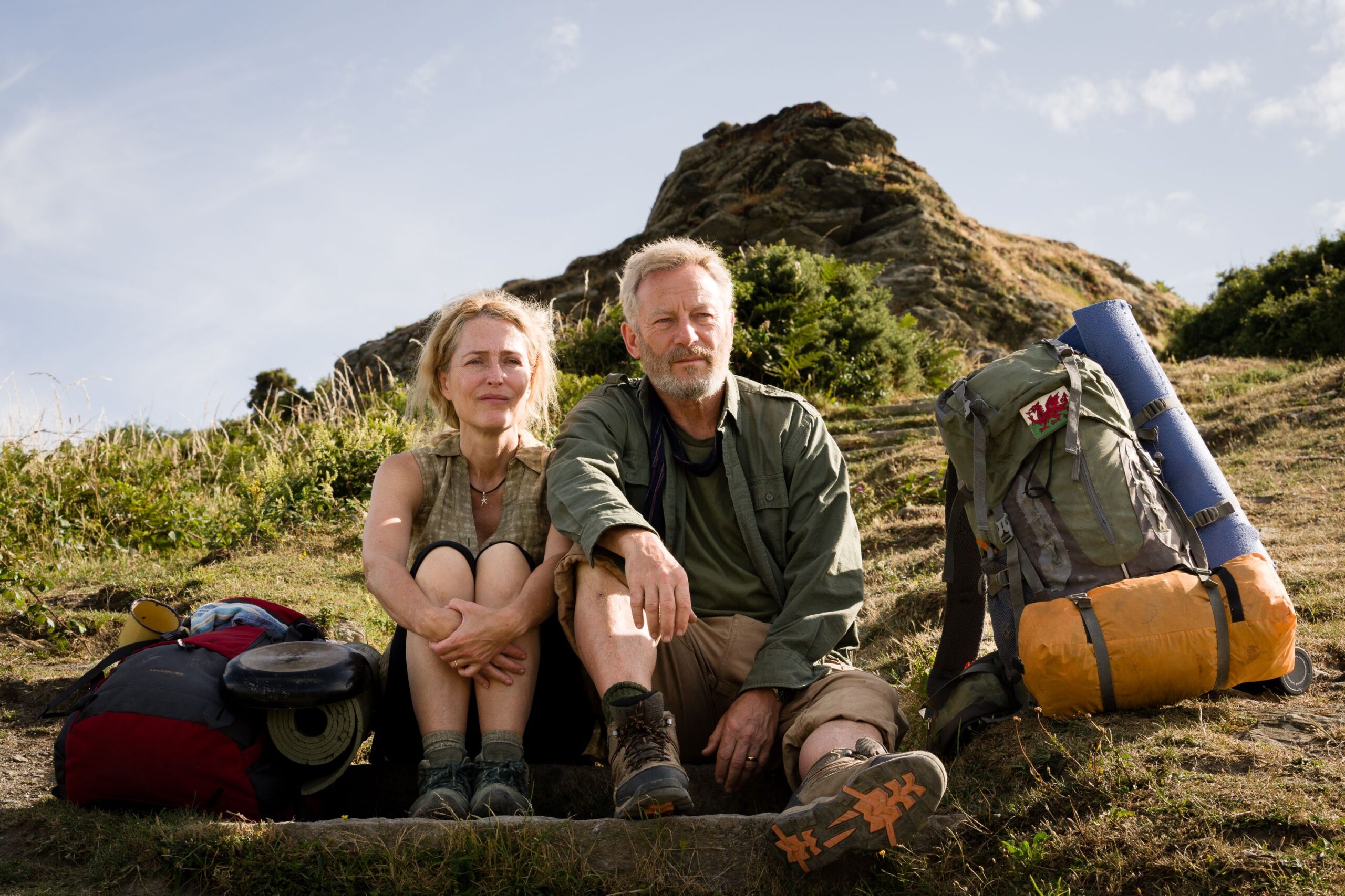
Guide books at the ready – the highly anticipated movie adaptation of Raynor Winn’s inspiring tale, The Salt Path, hits movie theatres tomorrow (May 30). It’s a story of love and resilience set on England’s iconic coastline and recounts the true story of Raynor and Moth Winn – played by Gillian Anderson and Jason Isaacs – who desperately hike along a 630-mile trail, the South West Coast Path, in search of solace and healing.
With stunning locations that include dramatic cliffs, vast beaches and tranquil villages, there’s hope from local tourist firms that the film will revive interest in Devon, Cornwall and Dorset, and the path that winds along the coast from Minehead to Poole Harbour.
“It is a joy to see the South West Coast Path depicted in all its breathtaking beauty as Raynor Winn’s breathtaking memoir is adapted for the screen,” Julian Gray, director of South West Coast Path Association, said. “The film captures the healing power of connecting with nature, the sense of freedom and the restorative impact that walking has on both mental and physical health.”
You may like
What is The Salt Path about?
In August 2013, Raynor Winn and her husband, Moth, set off from Minehead in Somerset to walk the 630-mile South West Coast Path. Though a series of unlucky events they had lost their home and all their money. Moth had been diagnosed with a neurodegenerative illness that would impact his strength and mobility.
They bought a tent and started walking as a way of coping with their circumstances. Miraculously, the more they walked, the more Moth’s condition improved; he got back more control of his arms and legs, so they kept going, surviving on small tax credit payouts from the government.
The story explores themes of survival and hope, and the power of the human spirit when faced with adversity.
Where is The Salt Path filmed?

(Image credit: Steve Tanner/Black Bear)
Set against the stunning landscapes of the South West Coast Path, the film adaptation of the book beautifully captures the rawness of nature, the challenges of the journey, and the connection between people and the natural world.
The path was designated a National Trail in 1978 and is now Britain’s longest National Trail. It is a 630m (1,014km) walking route that starts at Minehead in the county of Somerset, runs along the Devon and Cornwall coastlines and finishes at Poole in Dorset.
It is freely accessible and can be walked as a whole or as shorter sections. It passes through a National Park, five National Landscapes, two UNESCO World Heritage Sites, a UNESCO Geopark and a UNESCO Biosphere.
Key filming locations along the path include Minehead, Porlock, Hartland Peninsula, Clovelly, Newquay, Padstow and Rame Head. Find out more about them below:
Minehead
The coastal town of Minehead, on the edge of the Exmoor National Park, is the point that marks the official start of the South West Coast Path, and it’s where Ray and Moth begin their trip. It has a sweeping beach and promenade, and the South Coast Path Monument – a sculpture of two giant hands holding a map of the Coast Path, which is featured in the film. Ray and Moth set off on the path, part of the Minehead Maritime Mile Trail, then up to Culver Cliff.
Porlock

Vibrant heather and gorse on Exmoor with Porlock Bay in the distance (Image credit: Getty Images)
Picture-perfect coastal village Porlock Weir with its quaint harbor, charming cottages and stunning views is a highlight in the film’s locations. It is positioned on the Exmoor coastline and the old-world charm captures the essence of the area. The views over Porlock Bay are unforgettable.
Clovelly
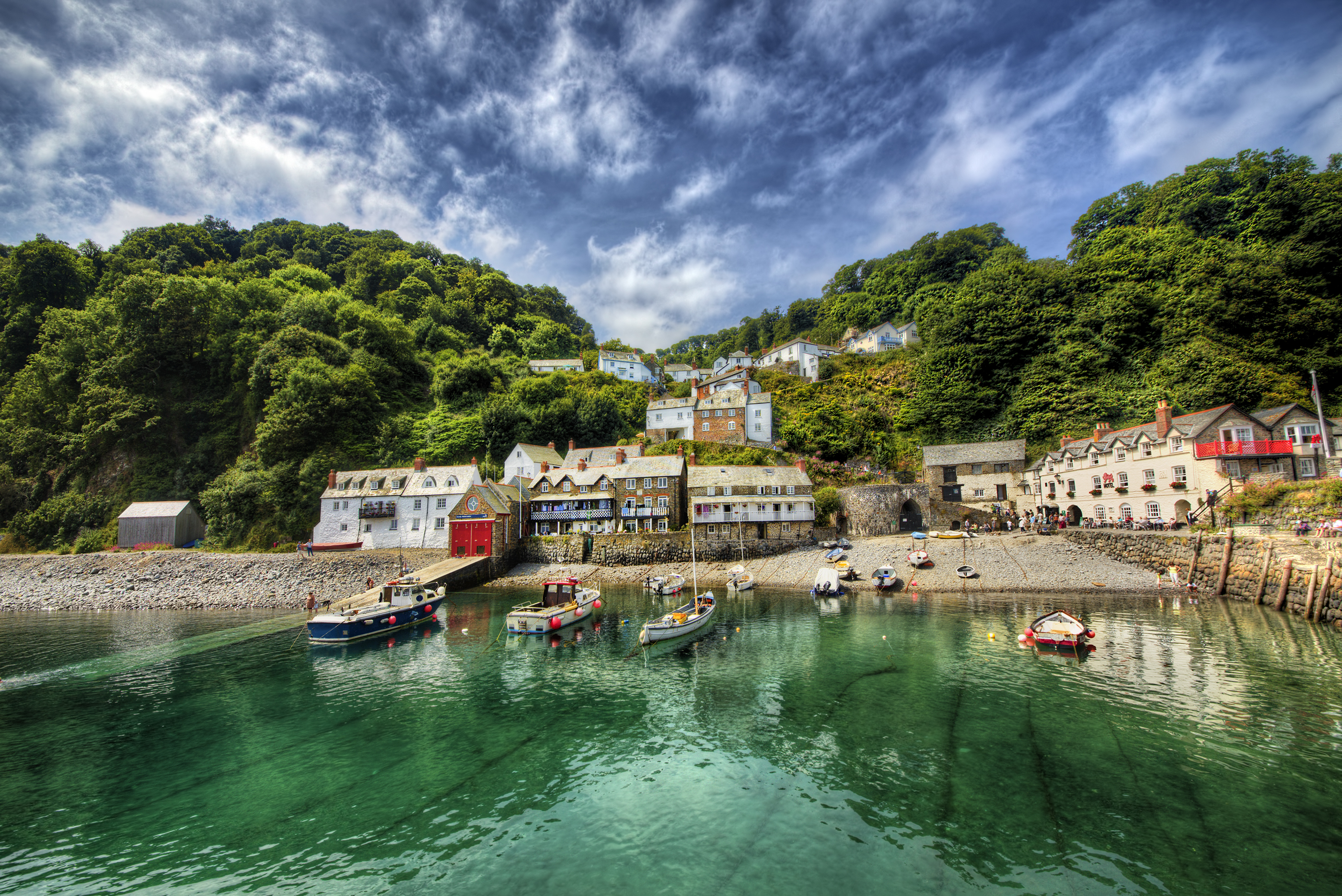
Clovelly is a picturesque fishing village in Devon that was once owned by the Queen of England (Image credit: Getty Images)
The iconic sloping streets of quaint fishing village Clovelly are where Ray and Moth take a detour from the path to hunt for food. Today, it’s a privately owned heritage estate where the cobbled streets and traditional architecture draw thousands of tourists each year. You have to pay to enter the village and no cars are allowed within its limits.
Hartland Peninsula

Hartland Point Lighthouse, pictured behind dramatic cliffs, marks the point where the Bristol Channel meets the Atlantic Ocean (Image credit: Getty Images)
Around Hartland Quay, a former harbor, and Hartland Point, a rocky outcrop, the coastline is dramatic, made up of high, jagged cliffs and huge rocky beaches. There are incredible coastal panoramas, and the area is rich in wildflowers and wildlife, making it a destination for nature lovers and photographers. Challenging gradients make this part of the trail an exhilarating walk.
Padstow
Padstow is another village where Ray and Winn take a break to immerse themselves among people in a bustling holiday destination, this time treating themselves to the British classic meal, fish and chips. The fishing village boasts tons of traditional charm with mesmerizing views of the estuary, and as they leave, rural Harbour Cove with its wide golden sands can be seen.
Newquay
Newquay’s world-famous beaches make an appearance, with their crashing waves and golden sands. Fistral Beach and close-by Watergate Bay are meccas for the surfing community, but Ray and Moth don’t stay long in the bustling holiday destination, preferring to head back to the solitude of the coast path.
Rame Head
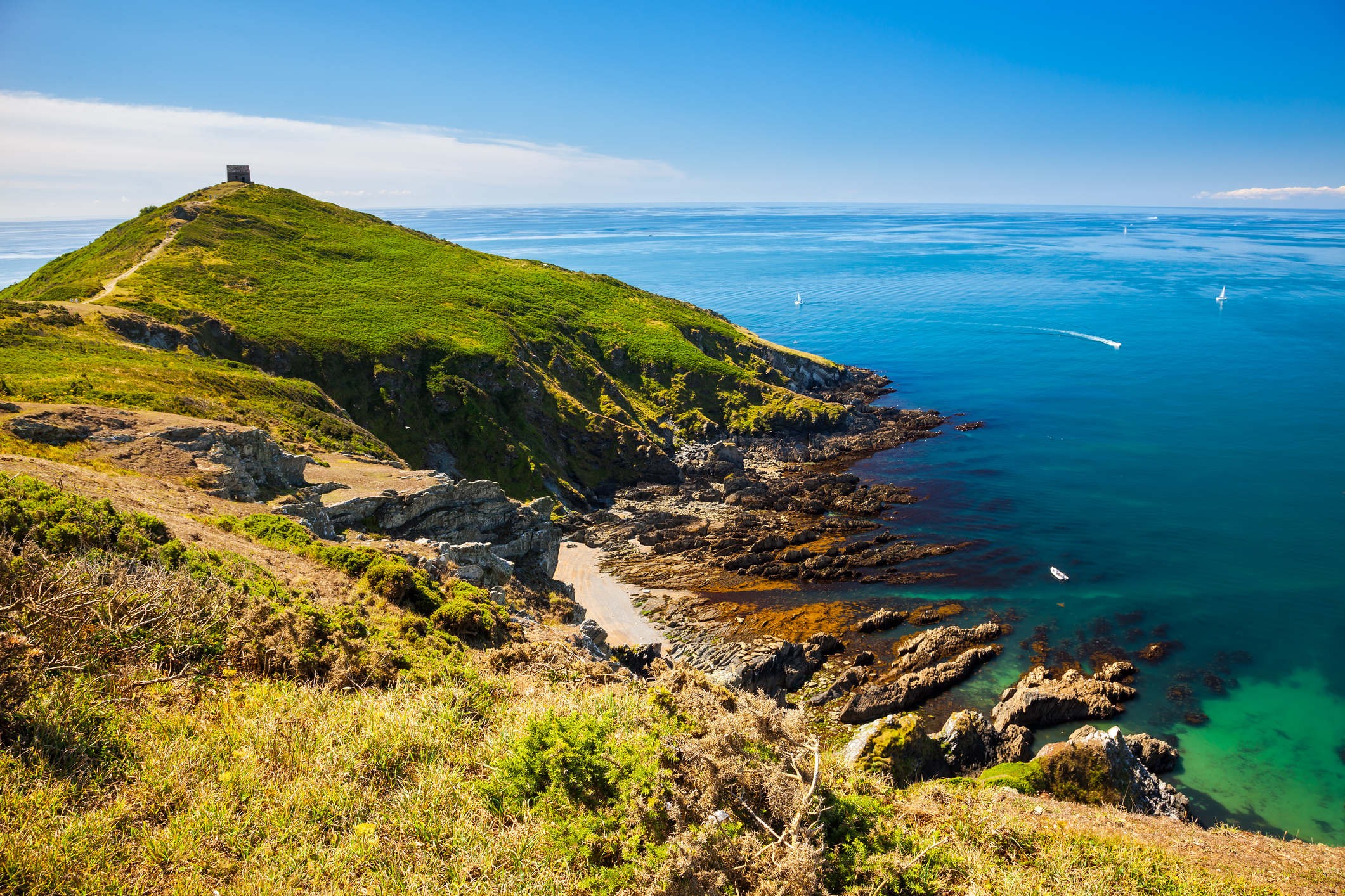
Rame Head is a dramatic headland with medieval chapel and incredible panoramic views (Image credit: Getty Images)
Rame Head, otherwise known as Cornwall’s ‘Forgotten Corner’ is the last location in the county of Cornwall before the couple head back into Devon. Rame Head, the beach of Tregantle, which is part of Whitsand Bay, and medieval Rame Chapel are all seen in the film. The dramatic headland once doubled as a hermitage and lighthouse and gives views of the sweeping coastline for miles in both directions. It’s a great place for bird spotting, so bring your binoculars.
How can I walk the South West Coast Path?
The South West Coast Path is a freely accessible walking trail that you can join from lots of different points along the route. You can walk small sections at a time or circular walks that link in with public transport. If you want to hike the whole trail in one go, The Official Guidebook to the South West Coast Path recommends a 52-day itinerary.
There are lots of affordable campsites on the path, where you can pitch a tent and meet fellow hikers. Visit the accommodation section of the South West Coast Path website for more information.
[ad_1]
Images are for reference only.Images and contents gathered automatic from google or 3rd party sources.All rights on the images and contents are with their legal original owners.
Aggregated From –
[ad_2]
Comments are closed.