



Original Coverage & Source Attribution: michaelrlowry.substack.com
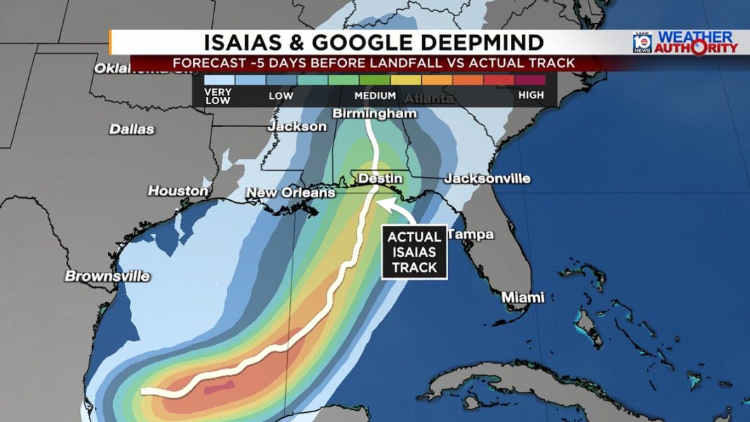
By now it’s old news to regular readers of this newsletter that Google’s DeepMind AI model is the one to beat when it comes to hurricane forecasting.
We were first to report on DeepMind’s mind-boggling performance as it happened in real time during its inaugural run last hurricane season and have written extensively about its performance and upgrades since, including most recently a full analysis of its blockbuster performance so far in 2026.
Now that AI hurricane models have finally hit the mainstream – with related stories this week from the New York Times, CNN, and other national outlets – it’s worth unpacking their differences. After all, not all AI models are created equal and new analyses from HurriLab, a North-Carolina-based weather tech company, show how other AI models stack up next to Google’s DeepMind powerhouse.
In comprehensive analyses conducted by HurriLab, three distinct camps of hurricane models emerged in preliminary forecast verification for Hurricane Isaias, which struck the Florida panhandle as a Category 2 hurricane a week ago today.
Using a probability-based performance metric called fair energy score – which weighs both track error and how closely ensemble members agree while adjusting for unfair advantages of larger ensemble systems – HurriLab found Google’s DeepMind AI-based hurricane model in a league of its own, with all current versions of DeepMind bunched up in a virtual dead heat at the top (green lines on the fair energy score plot). DeepMind came in with exceptionally low fair energy scores at every forecast time, demonstrating how consistently confident and accurate the Google suite of AI hurricane models was throughout Isaias’ time in the Gulf.
The European AI ensemble system that launched last July and the even newer GFS AI ensemble system that made its debut last December and is in its inaugural hurricane season both had solid showings during Isaias (blue and purple lines, respectively, on the fair energy score plot), besting their traditional physics-based counterparts (red lines labeled IFS ENS and GEFS, respectively, on the fair energy score plot) by a wide margin for forecast track.
In a distant third when it came to forecasting Isaias’ track were the legacy physics-based ensemble systems. Both conventional modeling systems whiffed on Isaias, with notably high fair energy scores and track forecast errors alone more than double the five-year average.
One of the wrinkles we discussed early on in Isaias’ forecast were the differences across models in both where and when Isaias would hit the northern Gulf. The traditional, physics-based modeling systems favored a weaker, slower-moving storm striking farther west (closer to Louisiana or coastal Mississippi). The AI models, on the other hand, leaned east (closer to coastal Alabama or the Florida panhandle) and advertised a stronger, quicker-moving storm through landfall.
Not surprisingly, the AI models also outshone the physics-based models in predicting the timing and location of Isaias’ landfall. Most impressively, Google DeepMind pinpointed landfall to within a few hours three days out while also being closest to where the actual center made landfall at Destin, Florida.
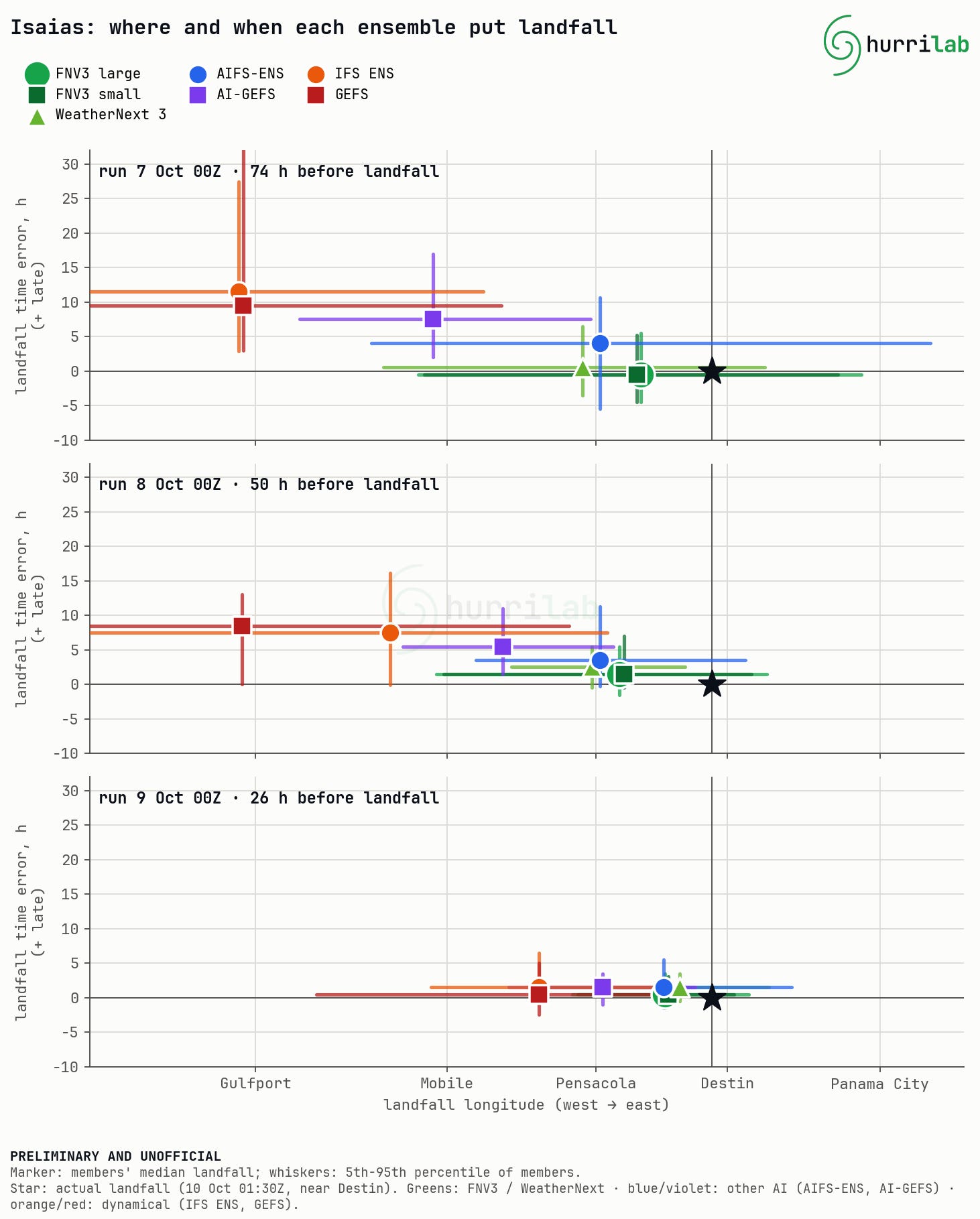
The physics-based Euro and GFS ensemble systems were not only too far west on landfall but too late on landfall by a full 24 hours or more. Missing the timing of landfall can put lives at risk for those preparing for or evacuating from threatening hurricanes so this was another huge success story for the AI hurricane models during Isaias.
HurriLab’s founder and CEO Dr. Wallace Hogsett, who launched the company in June after years as the National Hurricane Center’s top science officer, where he led the integration of AI forecast models, is quick to point to how accurate and consistent the AI models were during Isaias. “No weather model will ever be perfect in my lifetime,” Hogsett said, “but it seems to me like we are seeing a big jump in skill compared to the past few decades.”
The strong performance of AI models isn’t limited to Hurricane Isaias. It’s part of a broader theme of AI’s growing competitive edge, not only on the legacy physics-based forecast models but on human forecasters as well.
In preliminary season-to-date verification data compiled by former National Hurricane Center Branch Chief James Franklin, Google DeepMind continues to outpace the official National Hurricane Center track forecast across all storms in both the Atlantic and eastern/central Pacific basins.
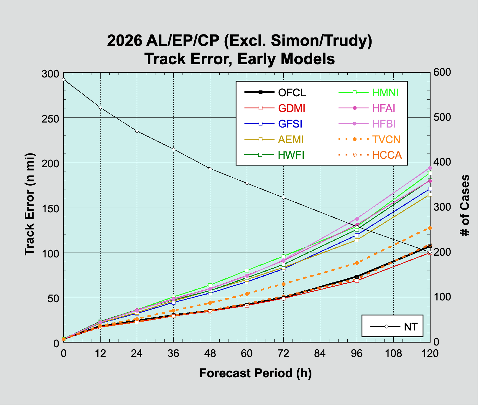
The human forecasters at the National Hurricane Center are well aware of DeepMind’s superior track record and incorporate it in blended consensus guidance like TVCN and HCCA, the latter which considers the strongest performing models and corrects for biases within each model. These blended models like TVCN and HCCA have traditionally been the guidance NHC looks to first since the consensus will typically outperform any single modeling system over longer periods.
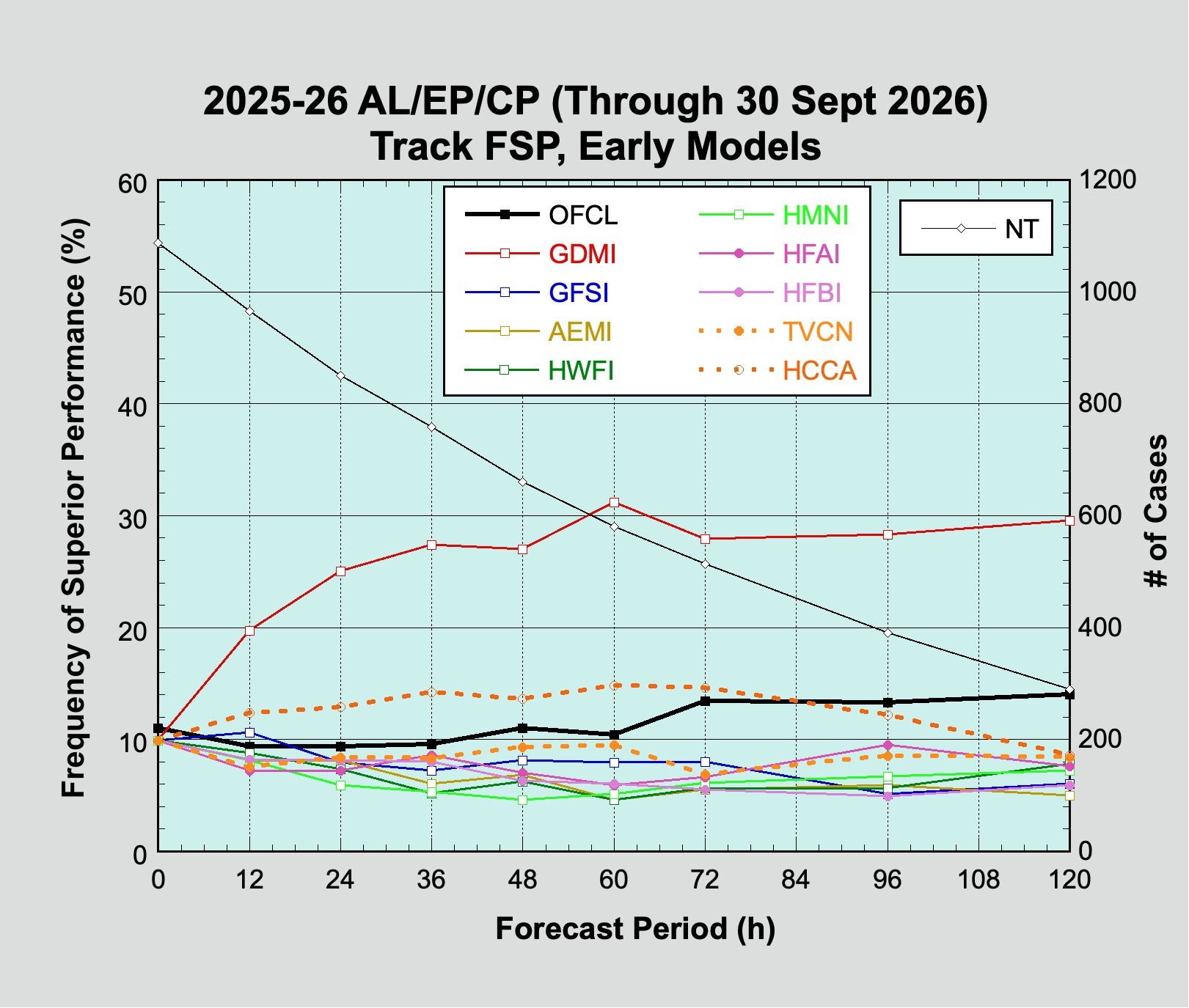
As Franklin shows, however, that hasn’t been the case over the past two hurricane seasons, with Google DeepMind having the most accurate track forecast a whopping two to three times more often than the consensus aids or NHC’s official forecast, which usually follows the consensus approach.
Even though AI models have proven they can not only compete with but also beat traditional, physics-based forecast models – which take longer to run and are more computationally expensive – for hurricane track predictions, they don’t always hold the answer key, especially when it comes to forecasting hurricane intensity.
We’ve already discussed how the Euro AI hurricane model has effectively negative skill in forecasting hurricane intensity due to a known issue with the low-fidelity data it’s trained on. Developers at the European Centre are aware of the issue and have identified a possible fix, but as of this writing the correction hasn’t yet been applied to its AI ensemble system. So for now, disregard the Euro AI model’s hurricane intensity forecasts, which systematically undercook intensity.
Google’s DeepMind is the only model so far to show skill in forecasting hurricane intensity. It’s been an impressive addition – among our best for predicting intensity – but overall our consensus aids like HCCA still show superior skill on the intensity side.
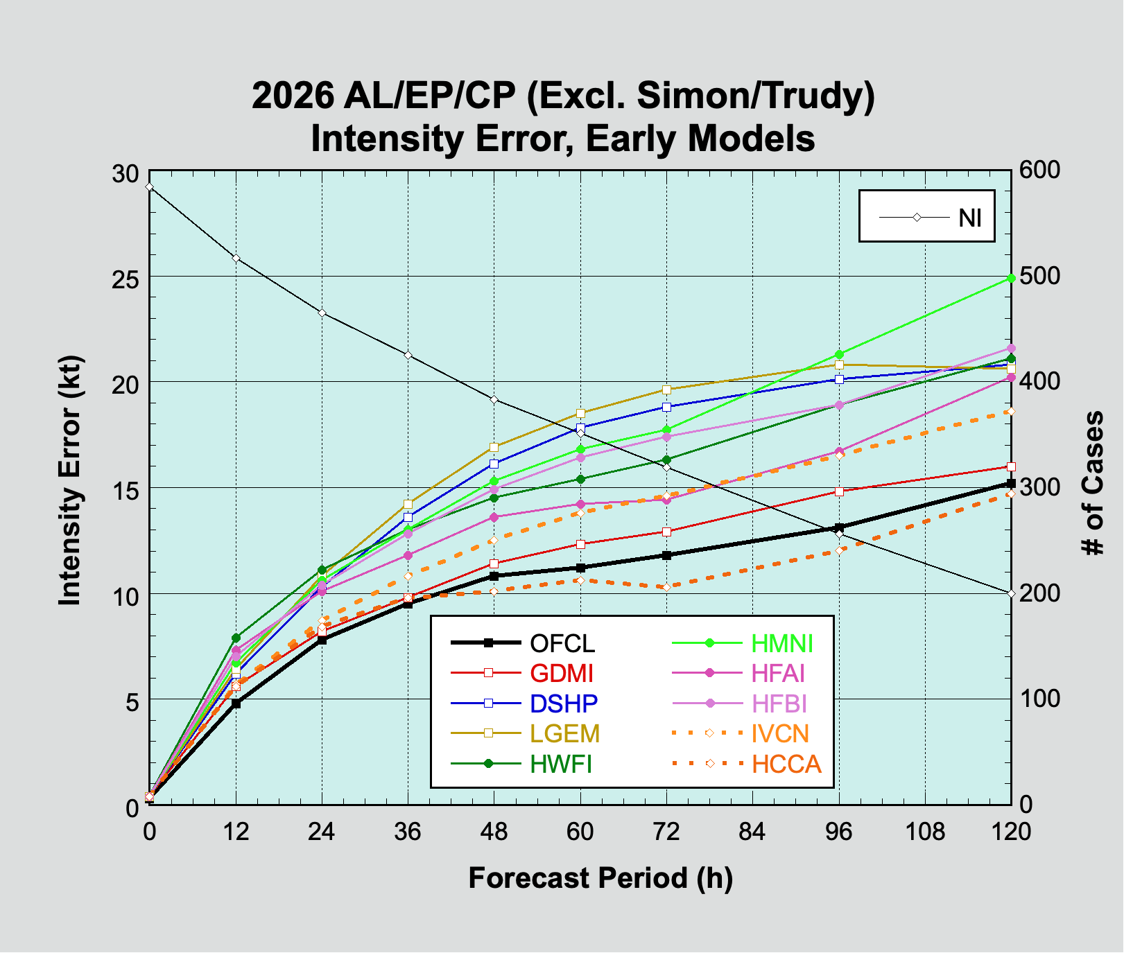
Even then, during Isaias it was the first-generation, high-resolution, and physics-heavy hurricane models like HWRF and HMON – models that have gone stale with the addition of the newer HAFS model – that had the best intensity predictions at longer time horizons.
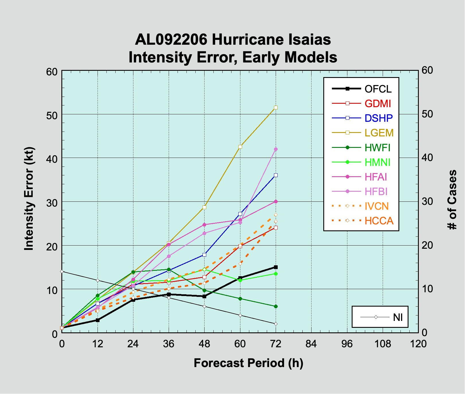
So despite all the AI hoopla, the legacy, physics-based models aren’t going anywhere anytime soon, especially for intensity. The AI models still can’t show us the important structural details of a hurricane that are often used by forecasters to diagnose and understand changes in track and intensity.
As we discussed in Thursday’s newsletter, an area of low pressure is forecast to form along a stalled front off the Carolinas by mid next week.
Models are still advertising the possibility of development for later in the week as the low-pressure area loiters near or east of the Carolinas.
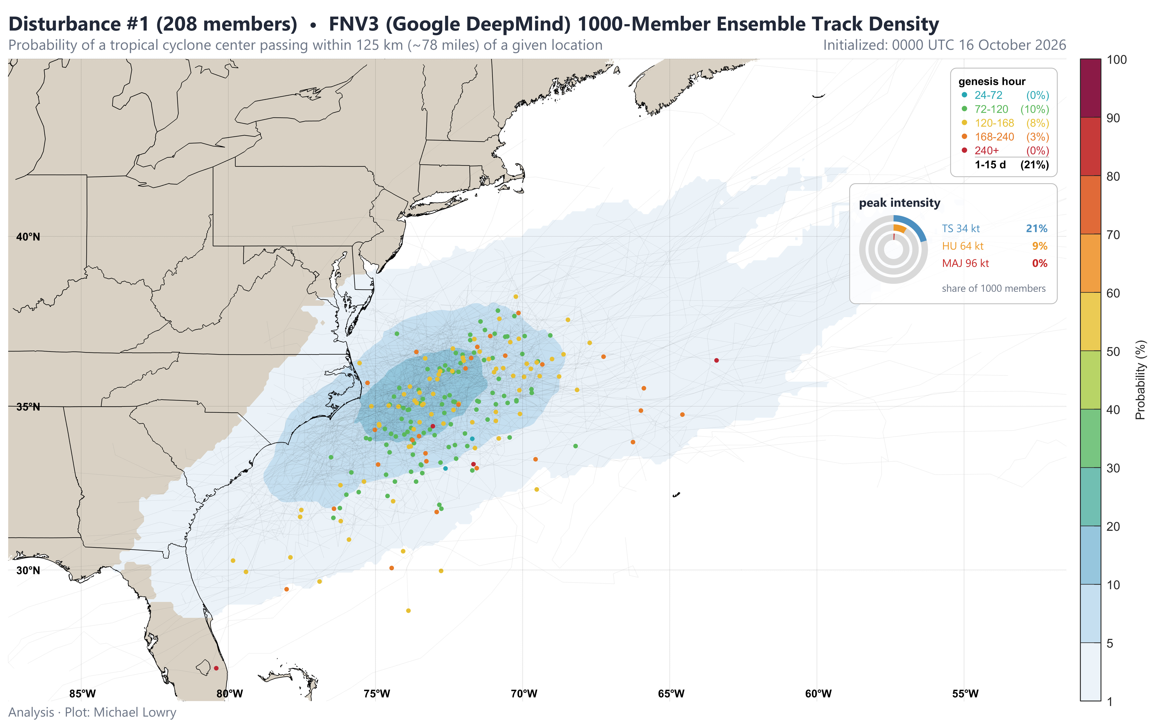
It’s to be seen if the low-pressure area will tap into the warm waters nearby and make a run at tropical or subtropical development.
Regardless, a tightening pressure gradient between the low-pressure offshore and staunch high pressure building over eastern Canada will create strong and persistent onshore winds along the coastal Carolinas by mid week, which could lead to prolonged coastal flooding, overwash, and beach erosion into late next week.